
Planning a trip through Maui’s rainforest can be overwhelming. It’s a choose your own adventure kind of trip where you’ll pass hundreds of waterfalls, grottos, caves, lava tubes, and beaches. Making every stop would take over a week and after a few days the waterfalls begin to blend together in your mind. To keep things interesting, we did a mix of hiking, chasing waterfalls, a bamboo forest, lava tubes, and beach hopping over two days.
We’ll cover my favorite spots along the drive listed by mile marker from Paia. Most of these stops are NOT labeled along the road so be sure to look out for mile markers and rely on your Maui Revealed book for parking and access tips. Be sure to read these driving safety tips if you’re planning your Road to Hana trip now.
We gave ourselves two days and one night to explore Road to Hana. Our journey started at 6am and I highly recommend getting on the road even earlier if you’re a morning person. Beating the crowds is key! These stops may be off the beaten path and take you out of your comfort zone. You won’t find most of these on a brochure of Hana. The top Hana stops for the adventurers are:
- Haipua’ena Falls (mile marker 11)
- Ka’anae Peninsula (mile marker 15)
- Ching’s Pond (mile marker 17)
- Hanawi Falls (mile marker 24)
- Nahiku (mile marker 25.5)
- Wai’anapanapa Black Sand Beach (mile marker 32.5)
- Red Sand Beach (Hana Town by the park)
- Venus Pools (mile marker 47)
- Pipiwai Trail and O’ehu Pools (mile marker 42)
Haipua’ena Falls (mile marker 11) We skipped the more popular falls, like Twin Falls, to beat the crowds and went straight here. This is one of the few small waterfalls you can swim under semi-safely.
Ka’anae Peninsula (mile marker 15) You’ll see an obvious pull off to enter the peninsula. Enjoy the views of small black sand beaches, the oldest church on Maui, and plantations. There’s a public restroom available here. Be careful visiting the black sand beaches here as locals are not friendly and may confront you.
Ching’s Pond (mile marker 17) This pond has handmade signs saying “locals only,” but fear not, this is public land and you can hike down to the pond for a dip.
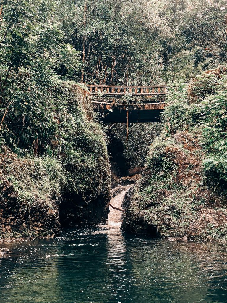
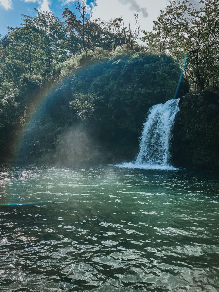
Hanawi Falls (mile marker 24) If you stop at one fall to swim this should be it. There were over 5 waterfalls that fed into a small pool and stream. This was definitely the best place to swim on the road if you’re up for a small rock scramble.
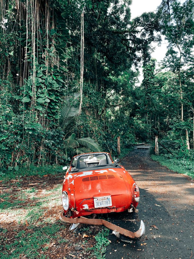
Nahiku (mile marker 25.5) The small plantation town has fruit stands and a dangerous one lane road. This is where I almost drove us off a cliff, but the views at the bottom of the road are worth the risky drive. We parked right before the old bridge next to a broken down red convertible and walked to the end of the road. You’ll pass the Nahiku swimming pond and a trail to the left of the ocean leads down to a secluded waterfall colliding with the sea. A private area to take a dip!
Wai’anapanapa Black Sand Beach (mile marker 32.5) This is not off the beaten path, but is a must-see on Road to Hana. Get here early in the day and leave time to hike around the area to see freshwater caves, lava tubes, a small blowhole, and black rock islands beyond the beach. This was one of my favorite spots and we spent over an hour here.

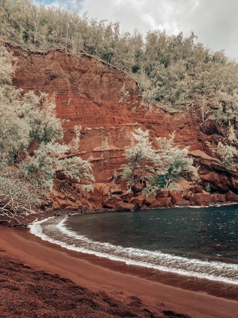
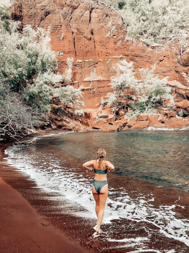
Red Sand Beach (Hana Town by the baseball fields) This was hands down my favorite stop and beach in Maui. I could spend an entire day here. This stop is dangerous with a 10 minute hike along a cliffside with no safety rails. The trail gives way to an amber beach unlike anywhere else in the world. Ironwood trees live among the steep fiery cliffs and multi-colored pebbles light up beneath the water. A unique lava formation protects the bay, but in high tide it can get dangerous to swim. I could visit Hana again to spent a full day visiting the black sand and red sand beaches.
Venus Pools (mile marker 47) A cliff jumper’s paradise. The 10 minute hike to arrive to the pools cuts through a cattle ranch and ends with a beautiful view of the spring and ocean fed pools. We arrived at high tide so it was deep enough to cliff dive about 25 feet down into the lower pool. Use caution and take a dip to test the depth before jumping! Sunset here was breathtaking.

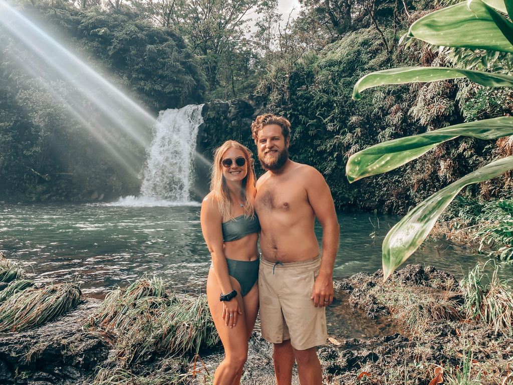
Haleakala National Park, Pipiwai Trail (mile marker 42) We were going to spend the night camping in the National Park, but it was closed due to COVID. Either way, we showed up at daybreak to hike the trails to the Seven Sacred Pools and Pipiwai Trail. Pipiwai trail is hands down the best hike in Maui with a bamboo forest, several waterfalls, a banyan tree, and the grand ending of Waiakeakua Falls. We lucked out that there were no clouds overhead so we were able to venture across a river to view the falls. Flash floods happen frequently so if there are any clouds overhead to not go past the cautionary signs at the end of the trailhead.

Haleakala National Park, ‘Ohe’o Gulch (mile marker 42) This gulch is better known as the Seven Sacred Pools. The seven pools reminded me of the Venus pools, but unfortunately waterfall access was closed in 2020 due to a broken monitoring system for flash flooding. If the falls are open and you have a chance to swim in the pools send me a photo so I can live vicariously through you!
Road to Hana was definitely the most dangerous place I’ve ever driven. Riskier than the tuk tuks of Vietnam and Cambodia! Don’t forget to read the driving tips, places to stay, and local taboos to plan your visit to these amazing sites. We stopped at dozens of other places along the road, but these were my favorite and the most adventurous places.


Your trip sounds wonderful!
We drove the Road to Hana on our first visit to Hawaii in 2000. The day before we rode the bike down the volcano. Absolutely amazing trip that started at 2:00 am so we could get up to the volcano for sunrise. Needless to say, we were exhausted doing the bike one day and the Drive to Hana the next day. We didn’t make many stops along the way, and it down-poured on us at one point, but it was a great experience! I have since learned to space our activities out 😊 Thanks for sharing!
LikeLiked by 1 person